TRAILS FOR MOUNTAIN TOURISM AND RECREATION IN THE NATIONAL PARK MAVROVO
General notes
The territory of the National Park Mavrovo, has many trails that can be used for hiking and mounatin biking. They have different difficulty, length and degree of usebility. Routes contained in this informational material intended for recreational mountain tourism and they are standardized and categorized by the Macedonian Association of International Mountain Leaders in accordance with international criteria.
All these trails are part of the cultural and civilization heritage of the Republic of Macedonia. For maintenance and infrastructure arrangement for the tourist and recretional trails cares National Park “Mavrovo” with expert assistance of professional leaders from the Macedonian Association of International Mountain Leaders.
National Park “Mavrovo” is not responsible for the personal safety of users of the paths and for save movement along the same, recommended mandatory observance of the rules of movement and residence for staing the mountains, using a complete equipment and hiring a professional mountain guide with a valid license to operate. If you like your recreation to be a real pleasure, do not leave the tour without backpack, appropriate hiking shoes, container for liquid, protective clothing for rain or snow, walking sticks, spare clothes, first aid equipment. If you decide to mountain biking, in adidition to equipment previosly indicated, we recommend mandatory use of protective helmet, and remind you that your bike should be in full technical correctness.
As we move in to the zone of pastures will encounter flocks of sheep that are accompanied by dogs, security guards, who in this situation react defensively to the flock, manifesting apparent aggression towards the visitor. But dogs are not aggressive, just doing their job to protect the flock. Аt a meeting with them is necessary to react calmly and wait to appear shepherd. Usually at the first communication you make with a shepherd they are reconciled. We should not react with fear and aggression or unnecessary to approach near the flock.
National Park “Mavrovo” asking visitors for caring behavior toward natural and cultural values in the park for their preservation for future generations.
Additional information can be obtained at the tourist info point of the national park Mavrovo on the phone: (042) 489 425
HIKING TRAILS
Trails in the area of Mavrovo valley and Bistra mountain
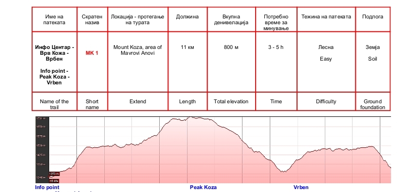
Info point – Peak Koza – Vrben
Nice recreational trail with beautiful views over the Mavrovo valley and region of the Gorna reka. It can be combined with the trail (road) to village Vrben. The base is comfortable for trampling and consists mainly of soil and grass. The trail is marked. Along the trail there are several sources of water, but because of their volatility, it is best to fill water in Mavrovi Anovi. From the top of Koza tour can be extended to cultural and historic site – Monastery St. Petka or to the safari park in the locality Bunec. Along the trail in many places has benches for resting, but no shelters and catering facilities.
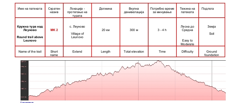
Round trail above Leunovo
Excellent multi use-path above the village Leunovo. Satisfies the appetites of all visitors, people who are recovering after illness, recreation, sports-oriented drivers, athletes on the preparations, as well as drivers on mountain bikes. Actually it’s technically forest path that can be used throughout the year. From April to November, the path is dry and good for hiking, running and mountain biking. From December to March can be used for ski mountaineering. The path is marked, and because it is technically forest path, the orientation is not a problem. The base is convenient for hiking and cycling. Because it is set in the forest belt, the hiking is pleasant throughout the day. Sources of drinking water has two places, but the path passes despite more streams. No technical difficulties.
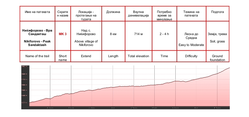
Nikiforovo – Peak Sandaktash
Old trail which is represented part of the cultural heritage of the park, because it is tied customs, events and legends that originate from the cultural tradition of the local population. The path starts from the center of the village Nikiforovo and stretching besides Petilepska river to Petti Leb. Here is the most wonderful source of drinking water in the park. From there, the hiking continues along the marked trail to the top Sandaktash (1981 m). The first part of the trail, from Nikiforovo to Petti Leb is in the forest. The second part from source to the top Sandaktash is in the zone of pastures where has the opportunity to enjoy beautiful landcapes and panorams. The trail is marked and main easy to follow. When there is fog, from Petti Leb to the top Sandaktash, it is mandatory hiking carefully and folow the singposts. Substrate along the entire trail is soft and comfortable for hiking. If you find yourself in the park on August 9, the day of Saint Pantelemon and day when village Nikiforovo celebreted, be sure to pass this tour to enjoy the unique experience and hear about the traditions of the region directly from the mouths of local population. Technical difficulties are insignificant, and the beauty and quality of the trail is invaluable. Drinking water is in the village and in the source called Petti Leb.
Round trail above Mavrovo
Excellent ”daily dose” for moderate recreational mountaineers situated in the village Mavrovo and it’s vicinity. Most of the trail is in the forest and therefore can be spent at any time of day and during the summer months. It is easy for orientation by following the markers and signs that are placed along the path. At several places the trail has mountain streams, but it is best to fill drinking water in Mavrovo.

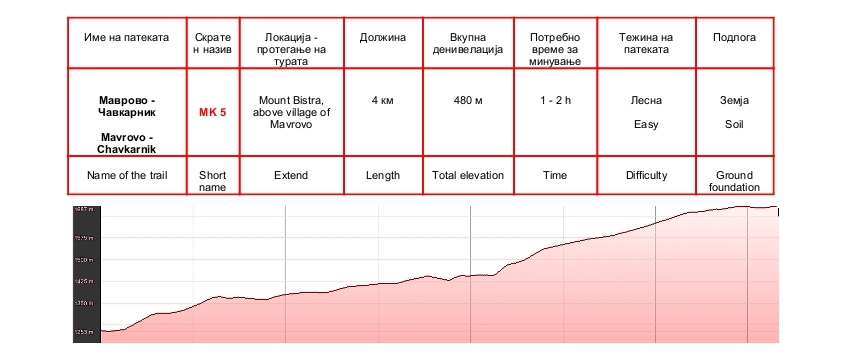
Mavrovo – Chavkarnik
This is an interesting trail with historical value because it is linked to traditions and customs of local people. The trail starts from the ski center in Mavrovo and ends at the locality Chavkarnik near the sheepfold. Beginning stretching through the forest and the final part is in the zone of pastures where you can enjoy the unforgettable panoramas and landscapes. The base is mainly soil and is comfortable for movement. Drinking water is in the sheepfold. The sheepfold may be extended to the ski fields or to the locality Petti Leb and top Sandaktash. When combining the trail with other trails in the region, mandatory use of the map.
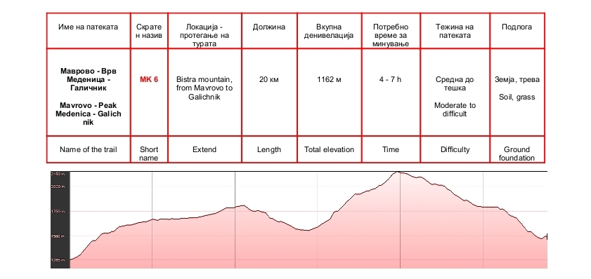
Mavrovo – Peak Medenica – Galichnik
A serious challenge to well-prepared hikers . The path is set mainly on open space and provides many beautiful landscapes and panoramic views over the Mavrovo lake, Bistra mountain and valley of river Radika. The trail is marked, but because it is a movement in the area of pastures, mandatory use of the map. Recommend hiring a professional mountain guide. For the most part, the ground is soft and moving along it’s enjoyable. At several places the trail merged with roads for motor vehicles, which provides an opportunity for differently to create the length of the tour. Total elevation in climbing mainly distributed at the beginning of the trail and from the point where the trail cut the asphalt road to the village Galichnik to the top of Medenica (2163). From the top to the village Galichnik the trail is climbingdown with a height difference of 750 meters, but with a balanced schedule and in most part by a soft surface. Drinking water only at one place (locality Boskova tap), so it is necessary to carry fluids in sufficient quantities (at least two liters per person).
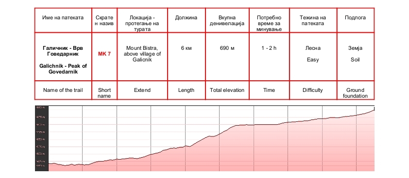
Galichnik – Peak of Govedarnik
A pleasant path that leads to the top Govedarnik (2011 m). During the hiking you will have opportunity to enjoy in wonderful panorama over Galichnik and wider region over Dolna Reka and Debar valley. To exit from the rocky gorge trail is visible and easy to follow, and from there hiking to the top of Govedarnik is turning to the right by following the delimitation and mountain slope. The main elevation be overcome before a rocky gorge in the initial part of the slope Govedarnik. The base of the trail is from a soil, rock and alpine grass. Technical difficulties are moderate. It takes careful hiking trough a rocky gorge. Safest drinking water is in the village Galichnik.
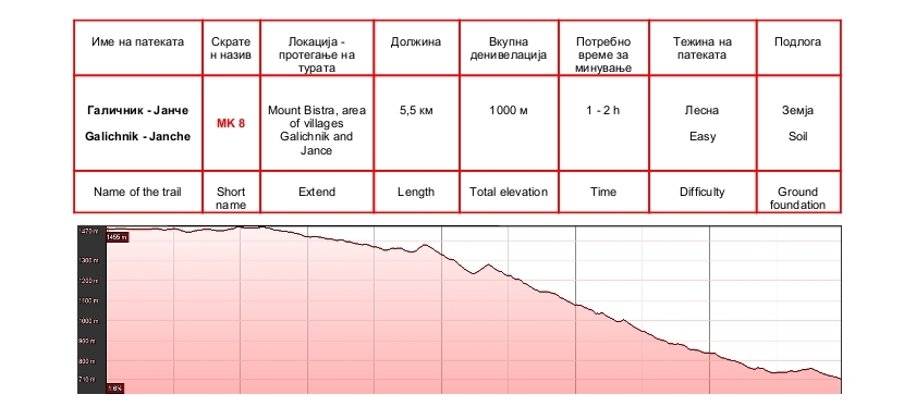
Galichnik – Janche
One of the historic trails in the region. The trail is old, as the villages and many things from this trail are related to the history of Galichnik and Janche. During hiking along the path, before the tourist are open the most beautiful panoramas in the region. The path is visible and easy to follow, and it is marked. The path has a source of water, called Sofino Cesmice. Very nice path that connects two important historical places in the region. The base is mostly soil, partly with a stone. No special technical difficulties.
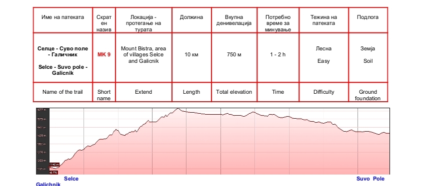
Selce – Suvo pole – Galicnik
Beautiful trail that connects the two beautiful villages and passing through picturesque Suvo pole. The trail stretches from the village Selce by village Suvo Pole before the village Galichnik. At the bottom is placed over Jadovska river, then climbs to the Suvo Pole, and from there to the village Galichnik. Partly set in a forest, and patrly in the zone of pastures. The path is visible, marked and easy to follow. It takes careful when exiting the first meadow despite Jadovska river, where you have to turn left to Suvo Pole. The ground foundation is soil and rock, but pleasant for walking. Drinkiking water has the sheepfold of Suvo Pole, but is best to fill from taps in village Selce or Galichnik, where which comes one of the finest drinking water in the park. Techical difilcuties are moderate.
GORNA REKA
Hiking trails in the area of Gorna reka
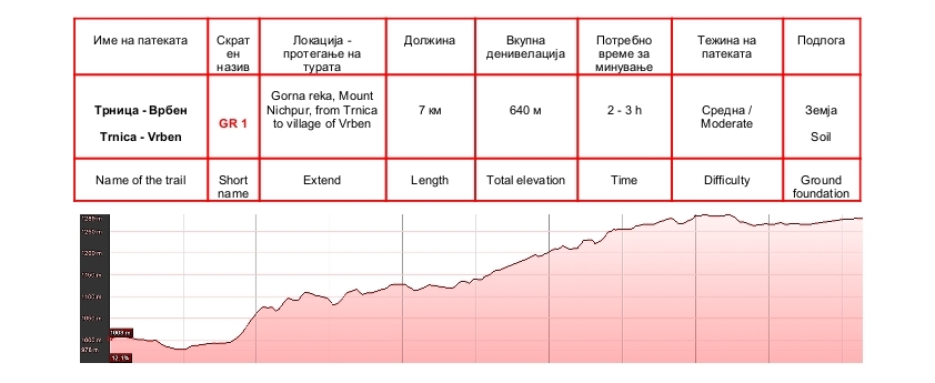
Trnica – Vrben
Interesting path over canyon of Mavrovo river and will lead you to the village of Trnica to the village Vrben or vice versa, depending on departure point. Hiking can be combined with trails who lead to the village Bogdevo so that you make a circular tour with longer duration and walk across a wider area of the park. The path is marked and it is easy to follow. The base is mainly soil, in places with a stone, but mostly pleasant for hiking. Partly set in a forest, and partly passes through the uncoated areas. Technical difficulties are small. Water for drinking is in village Trnica and in village Vrben.
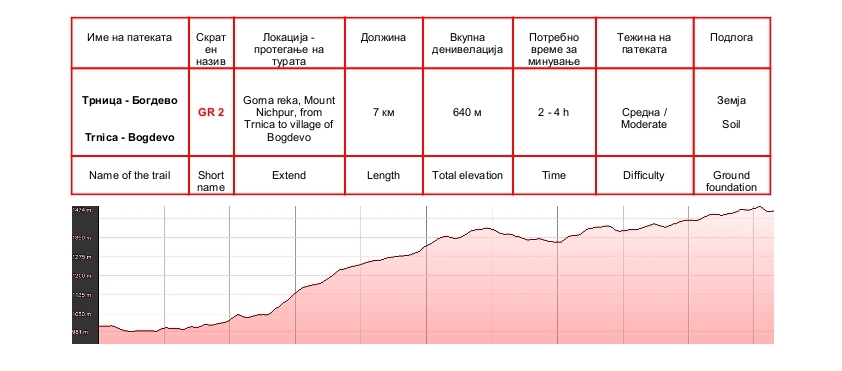
Trnica – Bogdevo
Very beautiful path, which will take you from Trnica to the village Bogdevo. From the debris of the old village architecture will be able to meet the cultural heritage and spiritual heritage of the Gorna Reka region. The path starts from the mountain house and camp of National Park Mavrovo in Trnica. Going trough the asphalt road Mavrovo – Debar and Mavrovo river, climbs despite abandoned village Trnica and continues to the village Bogdevo. The initial part of the trail passes through meadows, the lower part of the trail extends through the forest with low vegetation, and the upper part is located in dense forest. Climbing the elevation, is mainly in the first half of the trail. At about a mile before the village Bogdevo path is merged with the forest road from village Vrben to village Bogdevo. Technical difficulties are small. Water for drinking, has in Trnica and Bogdevo. Hiking can be combined with a visit to the village Vrben so that you make a circular tour whose beginning and end will be in the village Trnica. It abounds with beautiful landscapes and panoramas.
Trnica – Sence
One of the paths that must be visited. Offering a combination of recreation, enjoyment of cultural values and natural beauty of the park. Visit villages Belichica and Sense presents a journey through time, and hiking in the zone of pastures and the area around Senechki lakes, offers magnificent panoramas, landscapes and fantastic nature. Technical difficulties are moderate. The path is marked and mostly is easy to follow, but in conditions of fog and reduced visibility require increased vigilance. The base is pleasant for hiking. Drinking water has a few places along the trail, but it is best to fill in Belichica or in Sence. From Sence to Trnica can be used transport, or move along the path to Volkovija village and from there to Trnica, thus making a circular tour over Trnica. Very nice path.

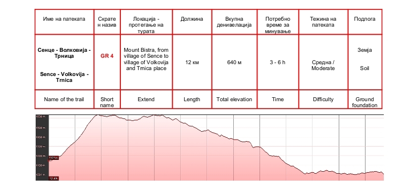
Sence – Volkovija – Trnica
Ideal tour for lovers of hiking through wild areas. The path is located on the rocky slopes of the canyon Radika overgrown with thick pine forest. Along the path opens up a wonderful view of the massif of Mount Korab. Elevations are mainly over the village Sence. The path is visible and marked, but it is necessary to move carefully because of the nature of the relief. The base is ground and in some places there are stones. Drinking water is best to use in the villages Sence, Volkovija or Trnica. Technical difficulties are moderate.
DOLNA REKA AND MALA REKA
Hiking trails in the area of Dolna reka and Mala reka
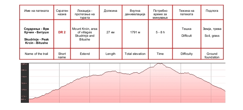
Skudrinje – Peak Krcin – Bitushe
This is a serious mountaineering challenge that allows movement through one of the most beautiful areas of the park. The path can start from the villages Bituse or Skudrinje, according to the place of residence. In the upper stretch of the highest parts of Mount Krcin, with an option to climb on top Large Krcin (2341 m). The peak can be climbed about an hour moving along the route is marked and starts from the sheepfold and a small church situated at the foot of the top. Very nice trail with many landscapes, panoramas and natural forms. For the most part the trail is clearly visible, marked and easy to follow. The base is soil grass and rock and generally a pleasant movement. In the lower parts is set in a forest, and from 1700 meters and higher in the zone of pastures. The three to four places, has sources of drinking water. Technical difficulties are moderate to high.
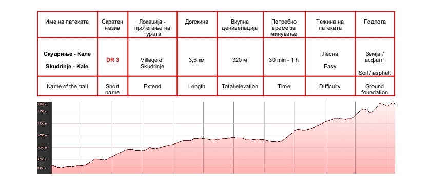
Skudrinje – Kale
Multiple path for different categories of tourists. Suitable for hiking, running and mountain biking. Contains a combination of sports, cultural and historical values. At the end of the trail is the archaeological site Kale. The first part of trail runs trough streets of village Skudrinje and the exit of the village, the sports fields, continuing a wide unpaved road, mostly set in the forest. The path is marked. Drinking water has in the village Skudrinje and another at two sites along the trail. Technical diffilcuties are small with the exception of the last sequence, scaling Kale where the movement is in steep rocky terrain.
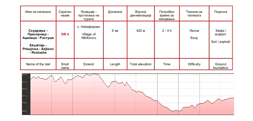
Skudrinje – Prisojnica – Adjievci – Rostushe
Old communications path that connected four villages from Dolna river region. The path is interesting and passing trough villages and provides additional value. The path is marked and easy to follow. The ground foundation is generally pleasant for movement and composition changes from goat path to technical forest road and the asphalt. Drinking water has in the villages. Technical dificulties are small.
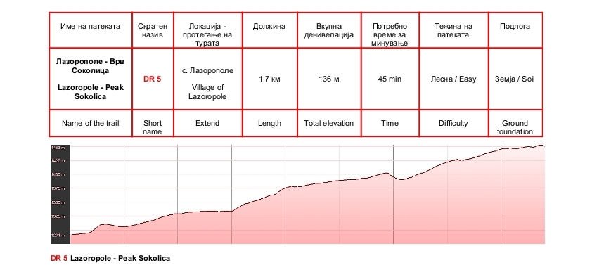
Lazoropole – Peak Sokolica
Easy and beautiful trail suitable for all categories of tourists. Most of the trail is set in the forest, so it can be passes at any time of day. Before Sokolica top (1471 m) there is a small church dedicated to St. Spas. The view from the top is incredibly beautiful. The base is soft and very pleasant for hiking as all trail. This is a short tour , which should be done. Drinking water is in the village. Technical difficulties are insignificant with the exception of the last ten meters below the peak where it is necessary to move carefully because of the rocky terrain.
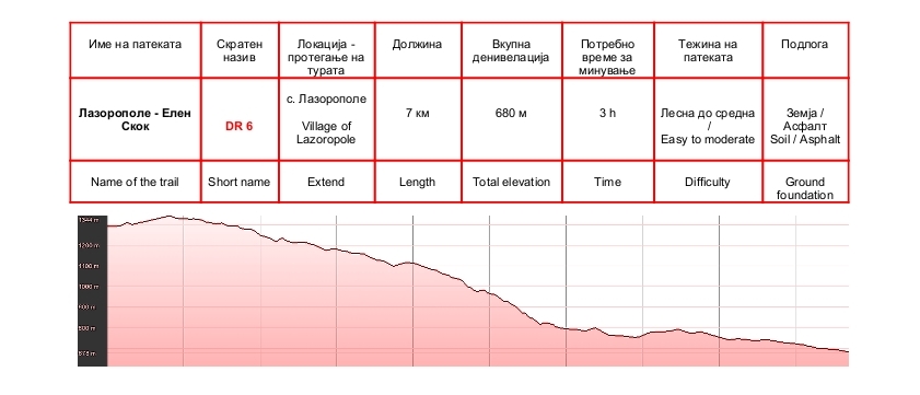
Lazoropole – Elen skok
Old and very beautiful path with historical significance. In the past it was the main trail from village Lazaropole to valley of river Radika. Under Vrteshka place at Garski bridge, the trail merged with the asphalt road to Boškov bridge. From there to the bridge Elen Skok is about 20 minutes hiking. The path is marked and easy to follow.Very beautiful water, is found in tap Lipovnik, about fifteen minutes from Lazoropole. Technical difficulties are moderate.
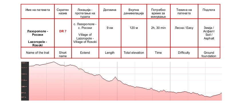
Lazoropole – Rosoki
Nice trail with great historical significance. Going through the historical sites, village Glavino and Kalina hole that are tied important stories of the history of Miaks. In the upper half of the trail are historic sites Glavino village , and fifty metars above the Glavino village is the cave Kalina hole. Many important events in the history of Miaks and village Lazaropole occurred in this location. The path is visible, marked and easy to follow. It is necessary more attention to the exit of Glavino village to direction Rosoki. Drinking water is found in localities village Glavino and Kalina hole. Technical difficulties are moderate.
MOUNT BIKE TRAILS
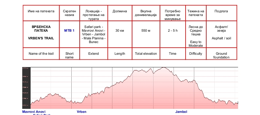
Vrben’s trail
This is one of the paths in the park that ”must be seen”. Excellent layout оf elevation and quality of the surface with many beautiful landscapes and panoramas. In addition, the road passes through beautiful village Vrben as though the safari park of national park Mavrovo, thus passing on the trail will not just ”usually” ride but also give the opportunity to enjoy cultural and natural values of the park. The road is a combination of asphalt, macadam and unpaved forest road and it is easy to follow and orientation. Along the way has set signposts and markers. Part of the way is in the forest and some in the zone of pastures. Drinking water has a few places, but is best to use water in Mavrovi Anovi or in the village Vrben. Technical difficulties are moderate.
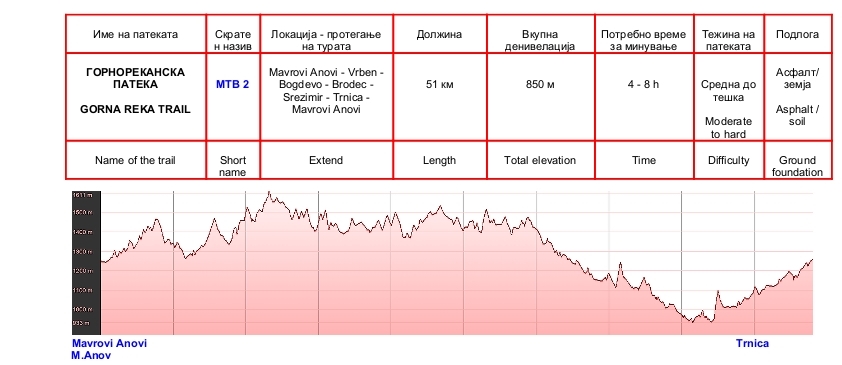
Gorna reka trail
Serious trail for riders who are physically well prepared. The trail begins at the tourist info point in Mavrovi Anovi and extend trough very beautiful scenery with wonderful panoramas over Gorna Reka region. The trail passes through three villages with authentic architecture and wild landscapes rich with a diverse flora and fauna. Most of the trail is set in a wide forest road with a hard surface, that is easy to follow and orientation and marked with markers and signposts. Drinking water has on several places. Catering facilities there despite Mavrovo lake and in the village Trnica. Technical difficulties are moderate.
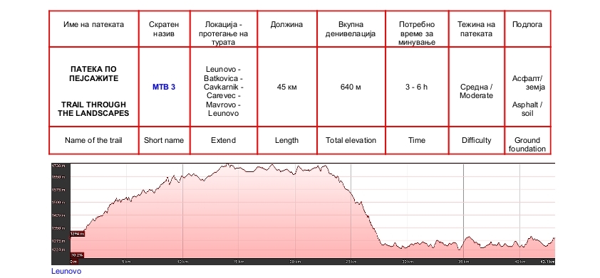
Trail trough the landscapes
One of the most beautiful trails for mountain biking in the National Park Mavrovo. As its name says, the path offers fantastic cycling experience by enjoying the beautiful landscapes and panoramas in the park. The starting point is just above the village Leunovo by the locality Studenche, where also is the formally end of this circular path. However, given that the park has a developed network of trails for mountain biking, the beginning and end of the tour can be adapted according to the wishes and the data from the map. Most of the trail stretching on a solid and wide unpaved road. Part of the trail is in the forest and part is in the zone of pastures dominated by beautiful vistas and panoramas. Some sequences of the trail coincides with the local asphalt roads. Orientation along the path is easy and along the same has many markers and signposts that clearly indicate the road. The four to five places along the trail has water to drink. Catering facilities has only besides Mavrovo lake. Technical difficulties are moderate.
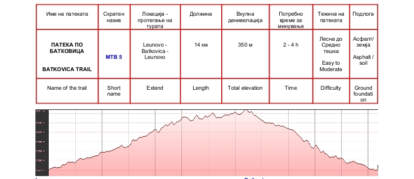
Batkovica trail
Batkovica path is short variant of the “Trail through the landscape” or the “Forest adventure.” The onset is in place Studenche, above the village Leunovo and through the locality Batkovica and Pejchino rechishte descends again down to the asphalt road around the Mavrovo lake near the west end of the village Leunovo. The road is unpaved, wide and easy to follow, marked with signposts and markers. Drinking water is best to use in the locality Studenche. Technical difficulties are moderate.
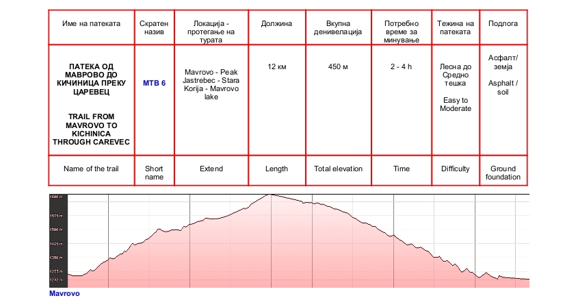
Trail from Mavrovo to Kichinica through Carevec
Very interesting trail trough beautiful woodland, which can be combined with other trails in the region. Because of its location in the forest can be ride in any part of the day. The beginning of the trail is by asphalt road from Mavrovo to Galichnik, before locality Carevec trail left the asphalt, turning to the right, where it starts driving down the wide and easy to follow forest road. Along the way, there are signposts and markers. Drinking water has on two places and it is best to use tap water that is beside the asphalt road to Galichnik. Technical difficulties are moderate.
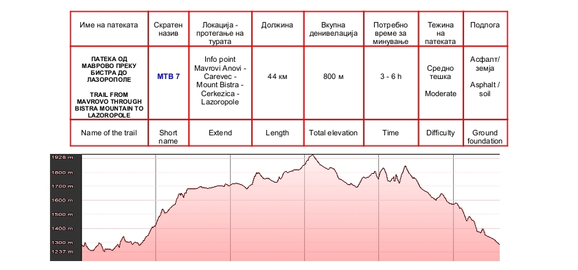
Trail from Mavrovo through Bistra Mountain to Lazoropole
Another path that trademark Mavrovo National Park as a destination for mountain biking. This is the path that must be tried for sports as well as for aesthetic reasons. Excellent landscapes and panoramas, wide road, comfortable driving surface, traditional architecture and passing besides several sheepfolds who have not only livestock but also cultural and historical significance, and provide the path attribute of the ”tour which should not be missed”. The trail begins at the tourist info point in Mavrovi Anovi and across to the asphalt road to the village Galichnik, stretching to the locality Carevec where leaves the asphalt and keeps driving through the landscape of pastures. A few kilometers before the village Lazaropole, in the locality Bachilishte path back into the forest. The road is wide, mostly unpaved, marked by clearly visible markers and signposts. Definitely one of the most beautiful path in the park and in Macedonia too. Drinking water has on several places. Technical difficulties are moderate.
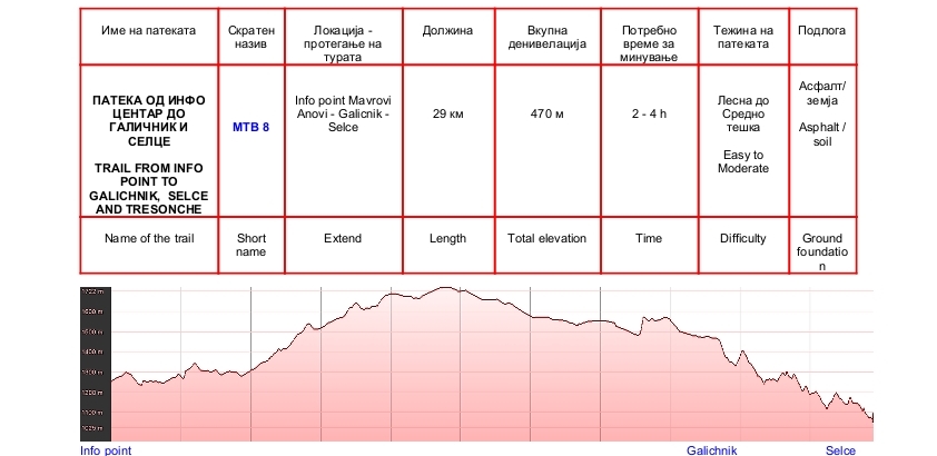
Trail from Info point to Galichnik and Selce
Beautiful trail that stretches across several areas in the park. The trail begins at the tourist info point in Mavrovi Anovi and across to the asphalt road to the village Galichnik. Before Galichnik besides football field leave the asphalt and drive along the wide and easy to follow forest road leading to the village of Selce. From the village Selce, on asphalt, the path leads down the road from the village Tresonche to Boskov bridge, from where it is possible to make different combinations of movement or turning back the same way. The road is marked. Drinking water has on several places and all are fantastic. If you want to enjoy the traditional architecture, visit the villages Galichnik and Selce. We recommend mandatory vacation besides the village fountain in Selce. Catering facilities there besides Mavrovo Lake and in the village Galichnik. Technical difficulties are moderate. At several places of unpaved road from Galichnik to Selce, you need to drive carefully.
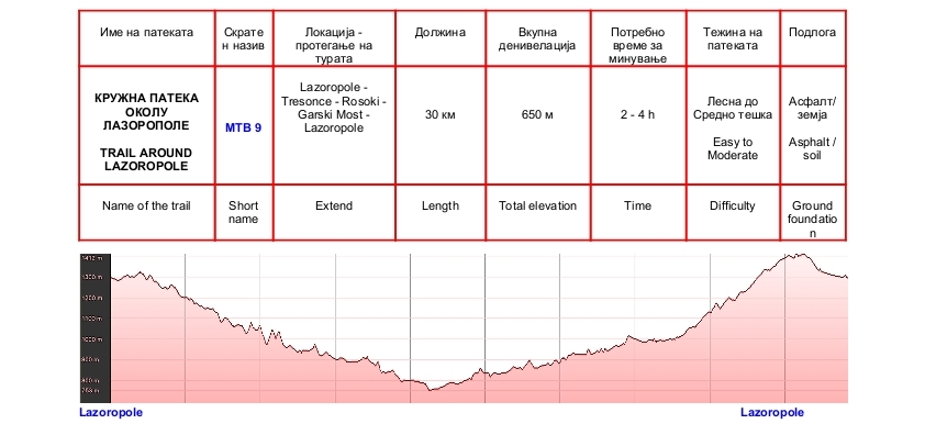
Trail around Lazoropole
Nice training for athletes and challenge for recreation. During two hours, pass through the most beautiful landscapes of the region Mala Reka.The path begins from the centar of the village Lazarapole and stretch of the unpaved road to village Tresonce. From there the ride continues along on the asphalt road besides Tresonechka river and Rosochka river to Garski Bridge, where you need to turn to the left to Lazarapole. The trail can be combined with other trails for mountain biking in the park, depending on the wishes and possibilities with obligatory use of the map. The road is wide, marked and easy to follow. Drinking water has on several pleaces. Catering facilities there in the village Lazaropole. Technical difficulties are moderate.